
Advanced Geological Services, Inc.
Malvern, PA 19355
Featured Project Return to Projects List
Seismic Surface Wave
Project Information
- Project Location:
- PA
- Status:
- Completed
- Structure Type:
- Misc Project
Scope Of Work
Project
A 5,400-foot alignment of a new gas pipeline was planned to be installed using horizontal drilling techniques, and AGS was hired to assess the thickness of a near-surface layer of “bay mud”.
Challenge
Due the presence of a federally-endangered species, the San Francisco Garter Snake, vehicles were not allowed onsite, which ruled out the use of intrusive investigation techniques like drilling or CPT work. In addition, saturated subsurface conditions caused by the shallow water table and the presence of a surface “cap” of fill material made standard seismic refraction methods unusable, for fear of erroneous and inaccurate results.
Solution
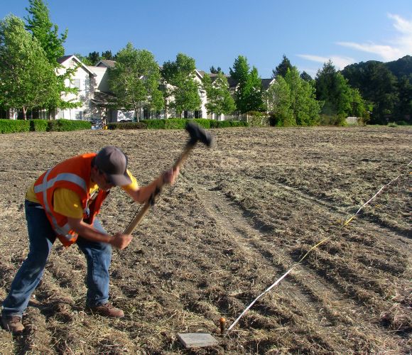
A seismic surface-wave survey was performed using a “hammer and plate” seismic investigation to assess the depth and thickness of the bay mud layer. Using a sledgehammer for the seismic source and with the equipment mobilized into cart that was hand-pulled along the alignment, the seismic survey had minimal impact on the site.
AGS obtained seismic surface-wave data at 55 locations using 115-foot long, 24-channel geophone arrays spaced 100 feet apart. AGS generated seismic energy through multiple impacts with a 16-lb sledge hammer against a metal plate placed on the ground surface at a shotpoint located 20 feet from the nearest geophone.
Results
The data from each array were processed separately to produce a 1-dimensional (1-D) velocity layer model depicting S-wave velocity variations with depth at a single point (which is assumed to be at the center of the geophone array). The 55 individual models were combined to produce a color-filled cross-section showing S-wave velocity variations both laterally and with depth along the entire proposed pipeline alignment. For viewing convenience, AGS also placed the individual 1-D S-wave models in their respective positions along the cross-section. In general, the surface-wave survey results show three subsurface layers: a surface “cap” of medium-velocity fill material, a middle layer of low-velocity mud, and the underlying higher-velocity sandstone formation.
Project Images
