GPR Data Inc.
Eugene, OR 97408
Featured Project Return to Projects List
The United States Navy Naval Air Station
Project Information
- Project Location:
- Kodiak, AK
- Status:
- Completed
- Structure Type:
- Airport Runway
Scope Of Work
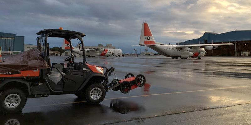
The United States Navy commissioned a naval air station on Kodiak in June 1941. Home to PBY squadrons early in World War II, Kodiak supported the Aleutian Islands Campaign of 1943, operating scouting and air transport squadrons. Thousands of metal anchors were installed in the concrete apron, to tie down the aircraft and anchor them safely against the extreme and unpredictable weather. In 1964, a 9.2 earthquake — the largest recorded in the United States – rocked Kodiak and buckled the concrete apron, rendering it unusable. To fix this, a thick layer of asphalt was added, smoothening the surface for aircraft use. However, wartime had passed, and there was no longer a need to secure hundreds of aircraft, so the tie-down anchors were buried and forgotten. In 1972 the site was turned over to the U.S. Coast Guard.
Fast Forward…
Over forty years, the apron surface was maintained by adding more and more asphalt. Although effective for a time, this tactic is ultimately unsustainable, as the weight of the asphalt continues to grow and the rate of deterioration multiplies. The asphalt surface needed to be reduced, milled down to a thinner point, for the resurfacing cycle to continue. Now, however, those long-forgotten tie-down anchors became a nearly insurmountable problem. Between the earthquake’s damage, the decades of settling, and added asphalt, there is no way to predict the depth of any tie-down. If the asphalt milling machine were to impact one of these tie-down anchors, equipment damage could quickly exceed millions of dollars. Trying to find these thousands of thin vertical loops in almost a million square feet of area would be like trying to find needles in a haystack… Needles that you can only see end-on, just the pin head.
Technical Challenges:
The technological challenges of accurately identifying these tie-downs with ground penetrating radar cannot be overstated:
980,000 square feet of surface area to scan. When you need to find objects as small as 2″, you need data every 2″. A 100′ x 100′ area is so exceedingly large that most providers won’t even attempt it. We did almost one hundred of these in a single project.
Unpredictable weather. During our field operation window, Kodiak island received 30% more than its typical heavy rainfall. As well as snow, ice, and beautiful sunshine.
Data volume. In an industry where datasets are usually measured in megabytes, we collected almost 250 GB of raw data on this project, and processed nearly 3 terabytes.
Software Limitations. We use the best ground penetrating radar equipment in the world, but even as good as it is, it simply wasn’t designed for projects of this scale. Our expert team of radar and software engineers developed custom in-house solutions to overcome native limitations with the GPR software.
Adaptability:
A fundemental pillar of GPR Data Inc. is our adaptabilty and this project showcased it. Throughout the project, our collection method evolved from a hand-pushed cart to a custom vehicle mount. Our backoffice methods evolved to conquer the inherent software limitations of the industry. Due to constraints of cost and looming winter weather, there was no luxury option to slow down and use conventional methods over the course of a year. We leveraged our unique combination of industry-leading field collection skills and in-house software engineering to conquer these challeges.
Project Images


