
Advanced Geological Services, Inc.
Malvern, PA 19355
Featured Project Return to Projects List
Landfill Investigation
Project Information
- Project Location:
- PA
- Status:
- Completed
- Structure Type:
- Misc Project
Scope Of Work
AGS performed a geophysical investigation to aid a City’s efforts to bring its old, inactive landfill into compliance with state and local Environmental Health regulations. Because compliance entailed the construction of a proper cover over the refuse area and the installation of a boundary fence to restrict public access, an accurate assessment of the actual extent of buried refuse with the 33-acre landfill site was needed. Accordingly, AGS performed a terrain conductivity survey using a Geonics EM31 terrain conductivity meter in combination with a magnetometer survey using a Geometrics G-858 gradient magnetometer. In addition, AGS used a Trimble Pro-XR Global Positioning System (GPS) to map the site and provide positioning information for the geophysical data.
Briefly, the EM31 measures the electrical conductivity of subsurface materials; it was used to look for conductivity anomalies indicative of both metallic and non-metallic refuse. The G-858 magnetometer was used to look for areas of buried metal and also to help discriminate between natural conductivity variations in soil conductivity and those associated with buried refuse, which usually contains at least some metal debris.
FIELD PROCEDURES
AGS performed the terrain conductivity survey by hand-carrying the EM31 instrument back-and-forth across the site along east-west lines spaced approximately 50 feet apart. Additional conductivity data were obtained along crossing north-south lines spaced from 50 to 150 feet apart and positioned to pass through areas barren of vegetation, which were suspected to represent concentrated pockets of refuse. The EM31 was programmed to obtain two readings a second, which corresponds to a conductivity reading every four feet along the survey lines. More than 48,000 line-feet (9 miles) of EM31 terrain conductivity data were obtained.
Next, AGS performed the magnetometer survey by hand-carrying the magnetometer along east-west lines spaced 50 feet apart. The MAG lines were offset from the EM lines to provide denser data coverage across the site. As with the EM survey, horizontal positioning data for the MAG survey were obtained using a backpack-mounted Trimble Pro-XR Global Positioning System (GPS). The magnetometer was programmed to obtain five readings a second, which corresponds to a MAG reading every foot along the survey lines. More than 28,000 line-feet (5 miles) of magnetic data were obtained. In total, AGS obtained more than 76,000 line-feet (nearly 14.5 miles) of geophysical data for this investigation.
After completing the geophysical data acquisition, AGS used its GPS to map prominent site features such as the roads, fences, visible refuse areas, and the areas barren of vegetation. The GPS map served as a basemap upon which the investigation findings and contour maps of the geophysical data sets are presented.
DATA PROCESSING AND ANALYSIS
The EM and MAG data processing and analysis was done using the GEOSOFT Oasis montaj earth science software system. A GEOSOFT kriging algorithm was used to prepare geo-referenced color-filled contour maps showing EM31 and magnetometer response variations across the site. Preliminary contour maps were prepared in the field for quality control purposes and to obtain and initial assessment of the extent of buried refuse. To facilitate the initial interpretation, the contour maps were placed onto the basemap the AGS prepared from the GPS mapping data. In an effort to correlate the geophysical responses to past landfill operations, AGS also overlaid the geophysics results maps onto historic aerial imagery provided by the City.
RESULTS
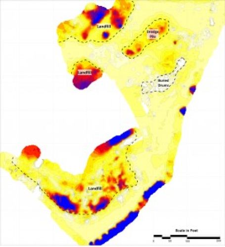
AGS identified a 14-acre area of anomalous EM and MAG response that is indicative of buried refuse (see Figures). EM anomalies indicative of buried refuse appear as both hot pink and dark blue colored areas, indicative of conductivity measurements above and below background readings (green areas), respectively. In some areas, the below-background EM readings show as negative values, which are indicative of large concentrations of shallowly-buried metal. Similarly, MAG anomalies (indicative of buried metallic refuse) appear as hot pink and dark blue colored areas, which are indicative of magnetic measurements above and below background readings, respectively. Due to the complex, dipolar nature of magnetic anomalies, magnetic data are often subjected to additional processing to help clarify its appearance on contour maps, especially when it is used to assess the extent of buried metal. This processing produces anomalies that appear as the “hot-pink” colored areas shown on the accompanying magnetic data figure. The EM/MAG anomaly area roughly corresponds to a large “dark area” (presumed burn waste) shown on a 1962 aerial photograph of the site, although the anomaly area extends approximately 280 feet northwest beyond the “dark area,” which indicates that refuse was placed in this area after 1962.
Several high-conductivity zones were also observed outside the interpreted buried refuse area. However; these particular high-conductivity zones are attributed to natural soil conditions, primarily, the accumulation of moisture and fine-grained material in drainage gullies. In addition, a number of localized metal-indicating EM and MAG responses were observed outside the interpreted buried refuse area. In most cases, these metal responses can be readily attributed to observed surface metal objects and none are considered to represent buried refuse.
Project Images
