EA Engineering, Science & Technology Inc
Syracuse, NY 13202
Featured Project Return to Projects List
Robert C Byrd Locks & Dam
Project Information
- Project Location:
- Gallipolis, WV
- Status:
- Completed
- Structure Type:
- Dams & Levies
Scope Of Work
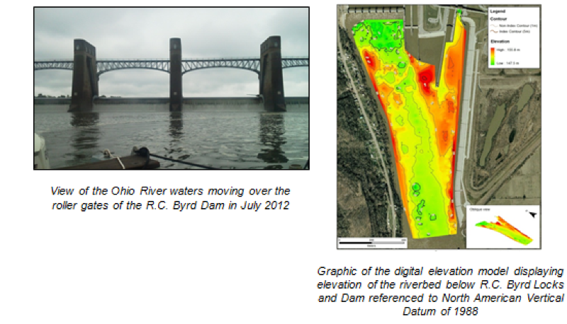
The Robert C. Byrd Lock and Dam, located at River Mile 279.2, was put into service in 1937, creating the R.C. Byrd Pool that extends 42 miles upstream to Racine Locks and Dam. The water flowing through the R.C. Byrd Locks and Dam forms the beginning of the Greenup Pool, which extends 62 miles downstream to the Greenup Locks and Dam. American Municipal Power, Inc. evaluated the feasibility of installing a hydroelectric power plant on the Ohio River at R.C. Byrd Lock and Dam and sponsored an assessment of the existing conditions in the project area and potential impacts in compliance with the Clean Water Act §404. As part of this larger assessment, EA completed a detailed benthic habitat assessment and flow study on the Ohio River in the Greenup Pool, just downstream of the R.C. Byrd Locks and Dam.
The survey activity was performed in July 2012 and required the collection of precision, single-beam bathymetry using real-time kinematic Global Positioning System/Global Navigation Satellite System methods for positioning in the horizontal and vertical planes, as well as the use of side scan sonar and an acoustic Doppler current profiler. Bathymetric soundings measured water depths within the Greenup Pool at the time of the survey and were used to generate a digital elevation model of the river basin in proximity to the dam referenced to North American Vertical Datum of 1988. The digital elevation model was then used in conjunction with acoustic river flow measurements obtained by the acoustic Doppler current profiler to establish and validate a comprehensive hydrodynamic flow model of the survey area that evaluated velocity and structure of flow through the survey area at various river stages and dam gate settings. In addition, the riverbed was acoustically imaged and subjected to groundtruth sampling, which aided in detecting the boundaries between areas of exposed bedrock, boulder and cobble fields, as well as various types of unconsolidated sediments that settle out of suspension downstream of the R.C. Byrd Dam.
These data types were used to assess existing conditions, then combined with the hydrodynamic model output. The goal of the data synthesis was to evaluate the potential for changes in the behavior of the tail waters (velocity, turbulence) moving over the dam and through the planned hydroelectric power plant, with an emphasis on possible impacts associated with alterations in downstream flow velocities, sedimentation patterns, and aquatic habitat for forage and recreationally important finfish species.